
Winter weather is returning to the Northeast, with the next major storm expected to move through Sunday night into Monday. Forecasts indicate notable snow totals, strong winds, and difficult travel conditions for millions from the Mid-Atlantic to New England.
What to Expect
Meteorologists are tracking a potent nor’easter that will likely strengthen as it moves up the East Coast. This system has the potential to rapidly intensify — a process known as bombogenesis — which can result in heavy snow, strong winds and lower pressure than typical winter storms.

Projected Snow Totals
Snowfall amounts vary widely by location and final storm track, but here’s a snapshot of the current forecast:
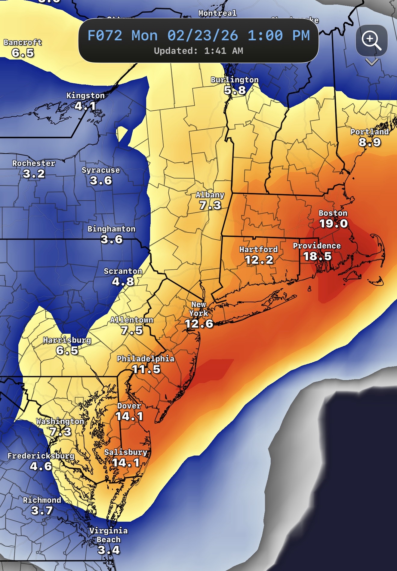
Boston, Massachusetts: 6–12 inches, with the highest amounts in Cape Cod, South Coast and island communities.
New York City & Long Island: Potential for 12–18 inches of snow in parts of the metro area.
Philadelphia and I-95 Corridor: 8–12 inches expected, depending on how close the storm tracks to the coast.
Connecticut: Southern portions could see 6–10 inches with strong winds; northern Connecticut more variable, with lighter accumulations expected initially.
Mid-Atlantic (D.C., Baltimore area): Lower totals of 1–6 inches likely farther south and west, though heavier snow remains possible if the storm tracks closer to the coast.

Every increase in coastal proximity can translate to significantly higher snow totals, which is why forecast confidence remains moderate and subject to change with new model data.
Timing and Travel
Snow will begin late Sunday, becoming steadier overnight into Monday. The heaviest snow and strongest winds are forecast during the Monday morning commute, potentially making road conditions hazardous.
Along the coast, strong onshore winds — possibly gusting over 40 mph — could contribute to blowing and drifting snow, reduced visibility, and pockets of coastal flooding at high tide.
Storm Facts: What You Should Know
Nor’easters are coastal low-pressure systems that can produce heavy snow, wind and coastal flooding when cold air combines with moisture from the Atlantic. Snowfall rates in heavy bands can exceed 1 inch per hour, increasing the risk of rapid accumulation and difficult travel. This winter has already brought multiple impactful storms to the region, and another significant system reinforces the pattern of active winter weather this season.
Safety & Preparedness Tips
Plan ahead for slow travel and possible school or work closures. Stock emergency supplies including food, water, flashlights, blankets and a fully charged phone. Keep up with local National Weather Service alerts, roads conditions, and any parking bans or travel advisories.