
A powerful winter storm is set to slam the East Coast this weekend, bringing blizzard-like conditions, heavy snow, strong winds and coastal flooding from parts of the Southeast through the Mid-Atlantic. Residents across the region — many still digging out from earlier snow and ice — are being urged to prepare for hazardous conditions and limited travel.

A Bomb Cyclone Takes Aim at the Coast
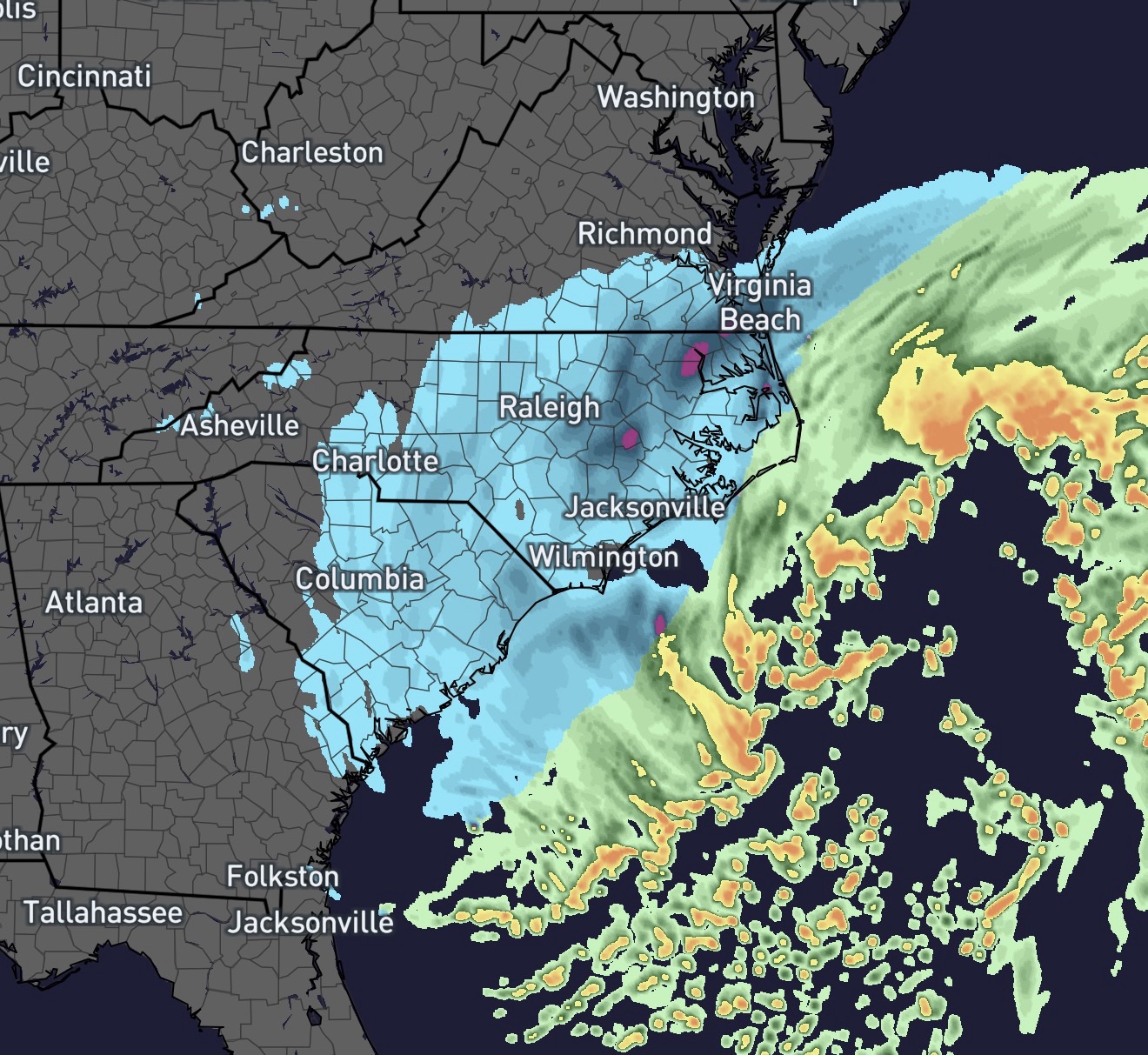
Forecasters say the low-pressure system will rapidly strengthen off the Southeast coast, a process known as bombogenesis, which can intensify storms into so-called bomb cyclones capable of producing hurricane-force winds and heavy precipitation. This weekend’s storm is expected to intensify quickly as it tracks northward along the Atlantic seaboard.
Late Friday into Saturday, snow will spread from the southern Appalachians into the Carolinas and southern Virginia, with the heaviest snow forecast from eastern North Carolina into southern Virginia and the broader Mid-Atlantic coast. Some areas could see 3 to 8 inches of snow, with isolated totals even higher along the coast.

Blizzard Conditions and Dangerous Winds
Coastal areas, especially from the Outer Banks of North Carolina northward to southeastern Virginia, are likely to experience blizzard-like conditions with strong winds and reduced visibilities, making travel treacherous or impossible at times. Wind gusts could exceed 60 to 70 mph near the coast, raising the threat of power outages, blowing snow and hazardous driving conditions.
Even if the storm tracks slightly offshore, forecasters warn that gusty winds and snow bands could still push hazardous conditions into the Mid-Atlantic region, affecting communities from southern Virginia into Maryland and Delaware.
Mid-Atlantic Preparations and Risks
Across the Mid-Atlantic, winter storm watches and warnings are in effect for portions of Virginia, Maryland and neighboring states. These areas can expect periods of snow and strong winds through Saturday and into Sunday, leading to slick roads, poor visibility and icy patches on bridges and overpasses.
Along the immediate coast, onshore winds and astronomical high tides will elevate the risk of moderate to significant coastal flooding, particularly at the peak of the storm’s intensity.
Travel Disruptions and Safety Warnings
Airlines and transportation officials have already warned of potential disruptions as winter weather threatens weekend travel, with cancellations and delays likely at major hubs along the East Coast. Road crews are preparing for extended operations to keep primary routes clear, but officials remind residents that staying off the roads during the height of the storm is the safest course of action.
Communities are also bracing for dangerous cold and wind chills far below normal. The Arctic air mass feeding this system is expected to plunge temperatures across the East Coast, prolonging hazardous conditions even after the snow ends.
Looking Ahead
By Sunday night into Monday, the storm will begin to move offshore, but lingering gusty winds and cold air will keep travel and outdoor activities risky. Residents should monitor local weather service updates and heed guidance from emergency officials.
The timing and exact path of the storm remain somewhat uncertain, so communities across the Southeast, Mid-Atlantic and Northeast are urged to stay informed and prepared as the situation evolves.